This sheet of questions asks students to work with latitude and longitude as well as to learn key terms that describe locations on the Earth that are of special importance to Astronomy. Students will need access to globes and the blank map at the end of this activity. They will also need rulers.
Earth’s Rotation and the Tilt of Earth’s Axis
The Earth is a rotating sphere. The Earth rotates about its axis once every 24 hours. The North Pole and the South Pole are the locations on the Earth’s surface that mark the axis of the Earth.
The axis of the Earth is tilted relative to its orbit by about 23.5° (exactly 23°26'21"). This tilt of the axis is what causes the seasons. The axis always points at the same location in the sky but as the Earth revolves around the Sun the axis points more toward or away from the Sun. This results in changes in how high the Sun appears in the sky. For example, on December 21st the Sun is at its lowest point in the sky for us in the Northern Hemisphere (everything north of the equator). On June 21st the Sun is highest in the sky. The opposite is true in the Southern Hemisphere: the Sun is highest in December and lowest in June south of the equator.
Latitude and Longitude
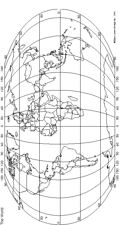
Latitude measures the distance, in degrees, that a location on the surface of the Earth is from the equator. The equator is an imaginary line that encircles the globe at the widest part: right in the middle between the North Pole and the South Pole. The equator has a latitude of 0°, the North Pole is at 90°N (+90°) and the South Pole is at
90°S (-90°). Lines of latitude are called parallels because they are all parallel to each other. Latitude lines run east-west and tell you how far North or South of the Equator you are. Latitude is one of two numbers that are necessary to give the coordinates of a location on the surface of the Earth. Scarborough, Maine has a latitude of 43°N (+43°).
Longitude is the other number that is necessary to uniquely identify a location. Longitude lines are called meridians. The word merdian comes from Latin, meridies, which means mid-day. Each line of longitude reaches noon at a different time and so each has its own meridian. Longitude lines run north-south and tell you how far East or West you are of the Prime Meridian. The Prime Meridian is the line of longitude that, by international agreement, has been defined as 0° longitude; it runs through Greenwich, England (near London). Scarborough, Maine has a longitude of 70°W (-70°).
Because latitude and longitude are measured in degrees they are broken down into minutes and seconds. A minute is 1/60 of a degree and a second is 1/60 of a minute. Coordinates can also be given in decimal notation: The Tropic of Cancer is 23°26'21"N which is 23.439167°N.
The Tropics and the Arctic and Antarctic Circles
The climate (a word describing general weather patterns) of a region is largely determined by the latitude. If a region lies in the tropics, within 23.5° of the equator, then the climate is likely to be hot with alternating periods of rain and drought. If the region is in the mid-latitudes, say from 30°N to 55°N, then the climate is likely to have the seasons we are familiar with here in Maine: Winter, Spring, Summer, and Fall. North of these latitudes the climate is generally cold and as the polar regions are approached there are times of the year when the Sun only briefly rises above the horizon at all in the Winter.
Some lines of latitude have names and are useful reference points in discussions of the seasons. The Tropic of Cancer is the line of latitude found at 23.5°N. It marks the northernmost reach of truly vertical sunlight. The Sun’s light generally falls on the Earth at an angle due to the tilt of the Earth. As the Earth revolves around the Sun this angle changes, causing the seasons. In the tropics during some parts of the year the Sun reaches the Zenith and shines down from directly above. On the Summer Solstice, June 21st, the Sun’s rays fall vertically on the Tropic of Cancer. Similarly, there is a line of latitude called the Tropic of Capricorn at 23.5°S. Vertical sunlight falls on that line on the date we call the Winter Solstice, December 21st.
The Arctic Circle is another important line of latitude. It is found at 66.5°N, 23.5° south of the North Pole. Above the Arctic Circle there are times of the year when the Sun is above the horizon all night. It is truly the land of the Midnight Sun. The Midnight Sun happens in the northern summer but in the winter there are days when the Sun never comes up. A similar line of latitude is near the South Pole at 66.5°S: the Antarctic Circle.
page break
Definitions
Define the following terms in your own words. For numbers 4 through 9 also give the latitude and longitudes that define the words.
latitude:
longitude:
Tilt of Earth’s Axis:
Equator:
Prime Meridian:
Arctic Circle:
Antarctic Circle:
Tropic of Cancer:
Tropic of Capricorn:
Norther/Southern Hemispheres:
Comprehension Questions
How many degrees does the Earth’s axis tilt from vertical? What effect does this have on the seasons?
Find the the Tropic of Cancer on the globe. Mark the Tropic of Cancer on your map. What is the latitude of this line?
Find the the Tropic of Capricorn on the globe. Mark the Tropic of Capricorn on your map. What is the latitude of this line?
Find the Arctic Circle on the globe. Mark the Arctic Circle on your map. What is the latitude of this line?
How far from the North Pole, in degrees, is the Arctic Circle?
Find the Antrctic Circle on the globe. Mark the Antrctic Circle on your map. What is the latitude of this line?
How far from the South Pole, in degrees, is the Antarctic Circle?
What is the connection between the arctic circles and the tropic circles?
Using Latitude and Longitude
Part I. Fill in the blanks below by using the globe. For lines where latitude and longitude are given, identify the city. For lines where the city is given, give the approximate latitude and longitude.
40°N, 116°E
Cairo, Egypt:
34°S, 18°E
22°N, 114°E
Jakarta, Indonesia:
34°N, 118°W
Lima, Peru:
51°N, 0°W
19°N, 99°W
Moscow, Russia:
Bombay, India:
1°S, 37°E
New Orleans, USA:
40°N, 74°W
43°N 70°W
23°S, 43°W
Seattle, USA:
Sydney, Australia:
35°N, 139°E
Toronto, Canada:
The following tables are only visible in the online version of these pages. They give the answers to the exercise above. A printable version is here.
Beijing, China:
40°N, 116°E
Cairo, Egypt:
30°N, 31°E
Cape Town, S. Africa:
34°S, 18°E
Hong Kong:
22°N, 114°E
Jakarta, Indonesia:
6°S, 106°E
Los Angeles, USA:
34°N, 118°W
Lima, Peru:
12°S, 77°W
London, England:
51°N, 0°W
Mexico City, Mexico:
19°N, 99°W
Moscow, Russia:
55°N, 37°E
Mumbai (Bombay), India:
19°N, 72°E
Nairobi, Kenya:
1°S, 37°E
New Orleans, USA:
30°N, 90°W
New York, USA:
40°N, 74°W
Portland, Maine:
43°N 70°W
Rio de Janeiro, Brazil:
23°S, 43°W
Seattle, USA:
47°N, 122°W
Sydney, Australia:
34°S, 151°E
Tokyo, Japan:
35°N, 139°E
Toronto, Canada:
43°N, 79°W
Part II. Now that you have found and identified all these world cities with their latitudes and longitudes mark them on your map.
 90°S (-90°). Lines of latitude are called parallels because they are all parallel to each other. Latitude lines run east-west and tell you how far North or South of the Equator you are. Latitude is one of two numbers that are necessary to give the coordinates of a location on the surface of the Earth. Scarborough, Maine has a latitude of 43°N (+43°).